Mapping Apps
mapping apps
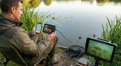
Using Tech in June Tench Fishing: Sonar, Mapping Apps, and Underwater Cameras
However, we must use tech carefully. Tench prefer quiet, calm waters with weeds () (). They do not like loud boats or crowds (). Studies show boat...
Mapping Apps
Mapping apps are smartphone and tablet programs that show your location on a digital map and help you plan and follow routes. They use GPS to track where you are, and they usually offer features like turn-by-turn directions, satellite or terrain views, points of interest, and the ability to mark or save places you want to return to. Many allow offline map downloads so you can use them without a phone signal, and some include layers for things like traffic, elevation, or weather. You can create routes, measure distances, share locations with friends, and search for services like restaurants, gas, or parking. These tools matter because they make travel and exploration easier and safer. They help you find the fastest route, avoid getting lost, and discover new places with less planning. For outdoor activities and boating, the navigation, saved waypoints, and offline maps can be especially useful when cell service is spotty. It’s important to remember limits too: battery life, GPS accuracy, and map data quality can affect performance, and users should take basic precautions like carrying a backup or paper map in remote areas.
Get New Fishing Research & Podcast Episodes
Subscribe to receive new research updates and podcast episodes about freshwater fishing, lake fishing, fish species, seasonal patterns, fishing tactics, bait, lures, rigs, and practical angling strategy.