Weed Mapping
weed mapping
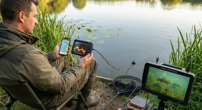
Using Tech in June Tench Fishing: Sonar, Mapping Apps, and Underwater Cameras
However, we must use tech carefully. Tench prefer quiet, calm waters with weeds () (). They do not like loud boats or crowds (). Studies show boat...
Weed Mapping
Weed mapping means creating a detailed record of where aquatic plants grow in a body of water. People make these maps using tools like sonar, aerial photos, satellite images, and hands-on surveys to show which areas are thick with vegetation and which are clear. The maps can show plant type, density, and depth, and they often include dates so changes over time are easy to track. For lake managers and conservationists, these maps are vital for spotting invasive species, planning treatments, and protecting important habitat. Boaters and anglers also use them to find fishing spots, avoid snags, and navigate safely through plants. Accuracy depends on the methods used and how often the maps are updated, because plant growth shifts with seasons and water conditions. Combining different data sources, like sonar with photographic confirmation, makes the maps more reliable. Interactive digital maps let users zoom in, filter by species or density, and even download coordinates for use with phones or GPS devices. By showing where vegetation is changing, these maps help prioritize management actions and measure whether those actions are working. Overall, mapping aquatic plants turns a scattered problem into clear, actionable information for people who care for or use waterways.
Get New Fishing Research & Podcast Episodes
Subscribe to receive new research updates and podcast episodes about freshwater fishing, lake fishing, fish species, seasonal patterns, fishing tactics, bait, lures, rigs, and practical angling strategy.